
Erection date: 2017
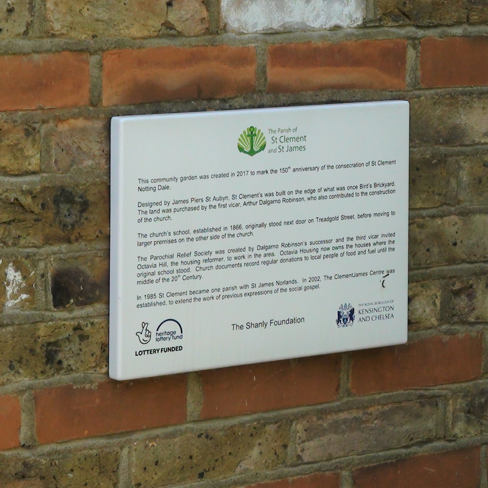
This community garden was created in 2017 to mark the 150th anniversary of the consecration of St Clement Notting Dale.
Designed by James Piers St Aubyn, St Clement's was built on the edge of what was once Bird's Brickyard. The land was purchased by the first vicar, Arthur Dalgarno Robinson, who also contributed to the construction of the church.
The church's school, established in 1866, originally stood next door on Treadgold Street, before moving to larger premises on the other side of the church.
The Parochial Relief Society was created by Dalgarno Robinson's successor and the third vicar invited Octavia Hill, the housing reformer, to work in the area. Octavia Housing now owns the houses where the original school stood. Church documents record regular donations to local people of food and fuel until the middle of the 20th Century.
In 1985 St Clement became one parish with St James Norlands. In 2002, the ClementJames Centre was established, to extend the work of previous expressions of the social gospel.
The Parish of St Clement and St James
Heritage Lottery Funded
The Shanley Foundation
The Royal Borough of Kensington and Chelsea
Site: St Clements Notting Dale - 150th anniversary (1 memorial)
W11, Sirdar Road, St Clements Notting Dale
The garden runs between the road and the church. A corner of the plaque is just visible in our photo, behind the railings, to the left of the white car.
There is a smaller garden beside the front entrance to the church, in Treadgold Street, which was also opened in 2018, to memorialise the dead of the Grenfell fire which tragic event happened in the June of the year that this anniversary garden was opened.
On 5 December 2017, at the special anniversary mass: "Bishop Michael also spoke of how St Clement’s was one of the first organisations in West London to respond to the Grenfell Tower Fire in the Summer of 2017, and the role which the church played in opening its doors at 3.00am on the night of the Fire, providing shelter to the survivors and refugees of the disaster."
An 1893 map shows where the schools were. The infants school was set back from Sirdar Road, immediately south of the church, almost certainly in the building that survives and Google Maps has labelled as "IntoUniversity Head Office". The boys and girls school was immediately west of the church.


Comments are provided by Facebook, please ensure you are signed in here to see them